THE NEXT STAGE OF THE EXPEDITION ‘SANTI ODNALEZC ORLA’ 2017 IS COMPLETED
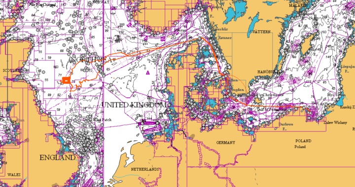
From May 20 to June 9, 2017, we have completed the next stage of the ‘SANTI Odnalezc Orla’ expedition which aim is to search and locate the ORP ‘Orzel‘, polish submarine sank at the bottom of the North Sea. As part of the expedition we continued the systematic bathymetric measurements started in 2015 in the immediate vicinity of the British aircraft carrier’s attack to submarine on June 3, 1940. The attack took place about 120 nautical miles off the coast of Great Britain at a latitude corresponding to the approximate location of Edinburgh.
Additionally, in order to maximize the potential of search, we have selected several interesting positions of possible wrecks on the route to the area of search, corresponding to the part of the historical return route of the ORP Orzel from the last patrol, and also on our return route, which corresponds to the possible return route of ORP Orzel from the A1 sector in which he was to perform his duties until June 3, 1940.
The searches in the immediate vicinity of the attack site consisted of systematical search of the whole area of the sea bed of adjacent strips of about 300 meters in width, sometimes exceeding 34 km. Good weather conditions and excellent parameters of the unit from which we conducted the measurements allowed us to maximize the use of the modern MBB SeaBat T50-P, which we had thanks to the cooperation with the Gdansk Marine Institute.
During the 12 days in the immediate vicinity of the airstrike, we were able to investigate approximately 900 km2 of the North Sea bottom in detail, excluding the wreckage of the ship sought up to 8 nautical miles from the center of the area. The total area surveyed in 2015-2017 is already over 1000 km2. In addition, we have conducted bathymetric surveys of the sea bed in a number of smaller areas at potential ORP sites during the last patrol, which we identified as possible wrecks. In one of the such area, about 5 nautical miles from the route that the ORP Orzel should return in June 1940 after the end of the operation, we have discovered a submarine wreck with parameters similar to the unit we were looking for. Detailed measurements of the found allowed to determine that it is 88 meters long and about 7 meters wide, so it is 4 meters longer than the searched ORP Orzel.
The query of archival materials and technical specifications of the submarines that operated and could have been sunk in that area, as well as the analysis of the wreck’s technical parameters, made it possible to point out that the discovered submarine was likely to be British HMS Narwhal, a torpedo mine vessel, type Porpoise. The ship departed on patrol on June 22, 1940 from base in Blyth to the coast of Norway, where she was to realize the task of mines of waterways used by the German navy.
She has not returned from a ptrol until June 30, 1940. It was assumed that she sunk in the vicinity of the Norwegian coast during the task. Finding a ship near the route of British submarines from patrols allows linking the cause of its sinking with the air attack of the German Do-17 Aircraft on an unidentified Allied submarine on July 23, 1940. Also, damage to the ship in the form of lifting a substantial portion of the deck’s deck between the kiosk and the stern of the ship is corroborated by the description of the air attack that resulted in the immediate hit of the bomb in the hull area. In other smaller areas and places of potential wreckage on the route to and from the surveyed area we searched around 40, in addition to the mentioned submarine we were able to find and investigate 29 different wrecks.
In the immediate area adjacent to the site of the British attack of June 3, 1940, during the current expedition we have found another 4, unknown wrecks of ships. This gives us a total of 10 shipwreck and wrecked wrecks (including wrecks found in 2015). Unfortunately, none of the wrecks surveyed matched the technical parameters of the wrecked ORP Eagle. This means that the navigational error that the British submarine poses as a submarine attack is more than 8 nautical miles (the smallest distance to the boundaries of the area under investigation).
During this year’s expedition lasting 21 days we sailed 3700 nautical miles and surveyed a total of 1090 km2 of the North Sea. The plans, except for finding the ORP Orzel, were fulfilled by us in 100%, allowing us to exclude the hypothesis, that the ORP Orzel wreckage was in the immediate vicinity of the position pointed out by the British pilot Lockheed Hudson as the place of the attack on June 3.
The results of our research works allow us to start planning exploration activities that we intend to continue in the coming years, but based on somewhat different methodological assumptions. Further exploration, given the size of the area that the wreckage may be, will be reduced to researching strictly selected facilities and fishing tackle sites, which we collect on a timely basis by supplementing our bases.
In summary, the scope of this year’s expedition, as well as the number of wrecks found and surveyed, exceeded our expectations, allowing us to recognize the expedition as the most efficient of our missions.

